★ REP YOUR TOWN ★ HOMETOWN GEAR ★ PRINTED TO ORDER ★ WHERE YOU FROM? ★ REP YOUR TOWN ★ HOMETOWN GEAR ★ PRINTED TO ORDER ★ WHERE YOU FROM? ★ REP YOUR TOWN ★ HOMETOWN GEAR ★ PRINTED TO ORDER ★ WHERE YOU FROM? ★ REP YOUR TOWN ★ HOMETOWN GEAR ★ PRINTED TO ORDER ★ WHERE YOU FROM? ★ REP YOUR TOWN ★ HOMETOWN GEAR ★ PRINTED TO ORDER ★ WHERE YOU FROM? ★ REP YOUR TOWN ★ HOMETOWN GEAR ★ PRINTED TO ORDER ★ WHERE YOU FROM?
Damaged in shipping or misprinted? Free replacement. Details
The Clarksville ridgeline, framed and ready to hang. Drawn from real elevation data for Clarksville, Tennessee.
Printed on museum-quality matte paper
Solid wood frame in black, white or walnut
Protective acrylic cover, hanging hardware included
Printed and framed to order in the USA
What's in this print
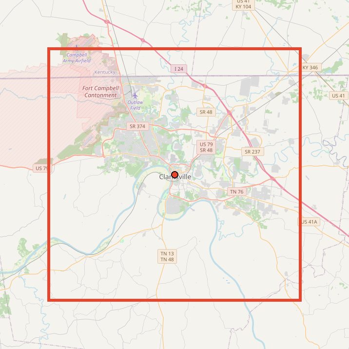
This one is real data. We took elevation data for a 20 x 20 mile square centered on downtown Clarksville, sliced it into west-to-east profiles, and stacked them from north to south. Every bump on every line is actual terrain, smoothed a little so the lines print clean.
Inside the square, the ground runs from about 359 feet along the river bottoms to about 764 feet on the highest ground, roughly 400 feet of relief. The flat lines are the valley floors along the Cumberland and Red rivers; the rise is King and Queens Bluff, with the Cumberland, Red River, West Fork Red River, Little West Fork, Spring Creek and Big McAdoo Creek all cutting through.
Yes. Each line is a real west-to-east elevation profile across a 20 x 20 mile square centered on downtown Clarksville. The map on this page shows the exact area.
Where do the high and low points come from?
The low points follow the river bottoms along the Cumberland and Red rivers, and the high points are the ridgeline of King and Queens Bluff above them.
What sizes and frames does it come in?
Two sizes: 11 x 14 in $79, 16 x 20 in $99. Frames come in Walnut, White and Black.
How is it made?
Printed on museum-quality matte paper and framed in a solid wood frame with a protective acrylic cover. Hanging hardware is included. Each one is printed and framed to order in the USA.
Does it come ready to hang?
Yes. It arrives framed, with the hanging hardware in the box.
Can I return it?
Each one is made to order, so we can't take returns for a change of mind. If it arrives damaged or misprinted, tell us within 30 days with a photo and we'll replace or refund it, free.